|
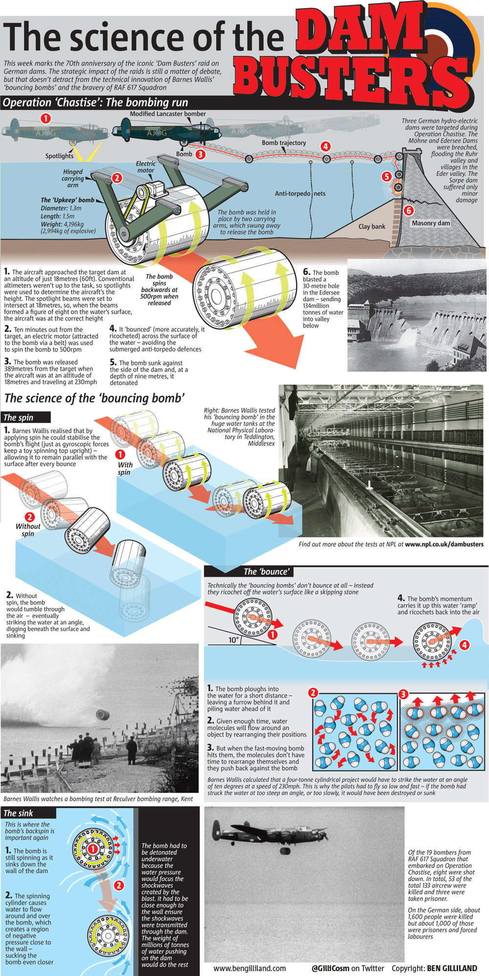
Today is the 75th anniversary of the famous Dam Busters raids, so I thought I'd mark it myself by sharing an infographic I produced for the Metro Newspaper on the 70th anniversary. On the evening of May 16, 1943, 19 modified Lancaster bombers set out from RAF Scrampton to attack the dams of the industrial Ruhr region in Germany. The planes of the newly-formed 617 squadron were carrying a very special ‘bouncing bomb’ that, although it would have very little impact on the outcome of the war, would ensure the aircrew that deployed it and the man who designed it would be forever remembered as the legendary ‘Dam Busters’. During the height of World War II, Bomber Command was tasked with destroying as much of Germany’s industry as possible. They had tried targeting factories but these were quickly rebuilt so they turned their attention to targeting the power sources that supplied them – coal mines, oil fields and hydroelectric dams. Coal mines were too easily repaired and the oil fields were too far away, so the dams, which supplied both power and water to industry, became the target. Unfortunately, they faced two problems: firstly, dams are (damn) difficult to destroy – after all they are strong enough to hold millions of tonnes of water at bay (only a very large bomb, or an underwater torpedo strike would do the job) and, secondly, Hitler was aware of the importance of his dams so they were well defended by submerged anti-torpedo defenses. The ‘very large bomb’ idea was abandoned because the RAF didn’t have an aircraft big enough to carry it, so it had to be the underwater option. But how would they get round the defences? Enter engineer Barnes Wallis. He had an idea that, rather than trying to breach the anti-torpedo nets, you could bypass them altogether by ‘bouncing’ a bomb across the surface of the water in the same way that you might skip stone across a lake – the difference being, his ‘stone’ was a four tonne bomb. The final bomb, called ‘Upkeep’, was a masterpiece of innovation and improvisation and, when it was deployed on the evening of May 16, it performed (almost) flawlessly. Of the three dams targeted during Operation Chastise, the Möhne and Edersee Dams were breached, flooding the Ruhr valley and villages in the Eder valley– the third, the Sorpe, was only lightly damaged. If you are struggling to read the text (since it doesn't really get any bigger when you click on it), feel free to right click and download (or just drag to your desktop) and you will get a slightly more readable jpeg.
3 Comments
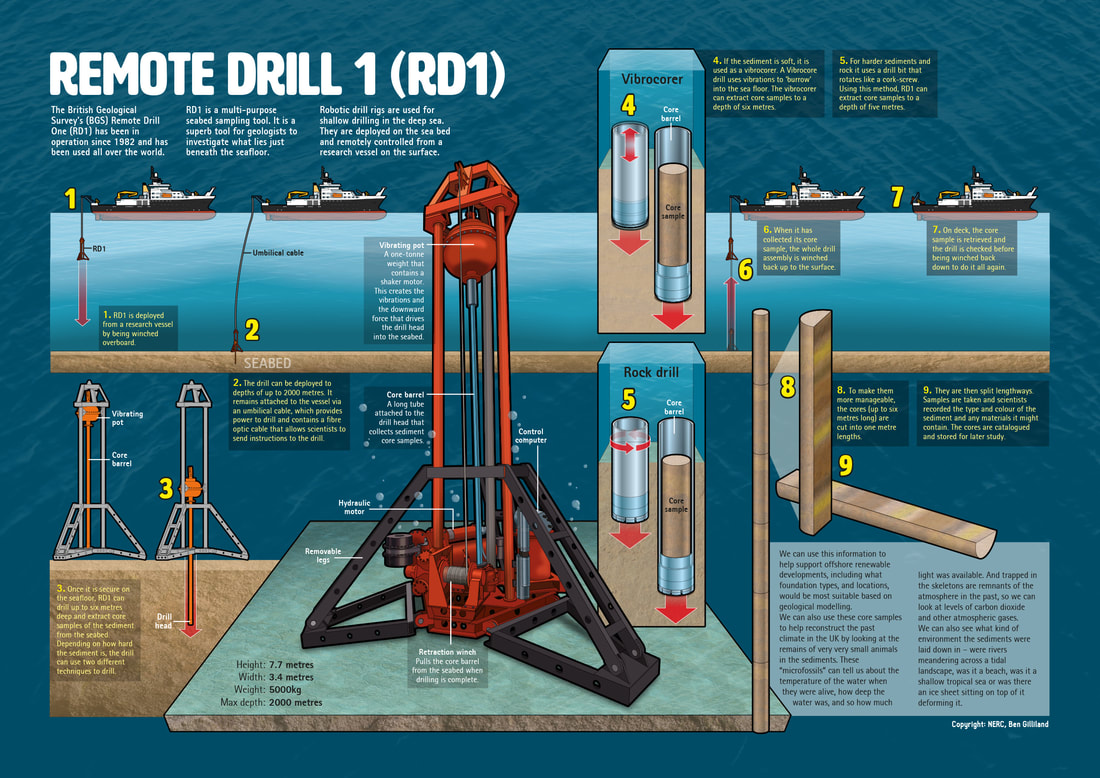
You wait a lifetime for a project about boreholes to come along and then two arrive at once! Following hot on the heals of their geoenergy drilling project, this infographic for NERC (Natural Environment Research Council) plunged me deep beneath the waves with their Remote Drill 1 (RD1). RD1 isn't new – it's been in use since 1982 (which is pretty impressive in itself), but it is still a very cool piece of kit. The drill, which is lowered from a ship and placed on the seafloor, uses vibrations to drill deep beneath the seabed and extract cores for study. NERC wanted the infographic to use as a poster for a public outreach event, at which the star attraction was the drill itself. I also provided reformatted pull-out elements for use on social media and online as well as version for use in NERC's Planet Earth magazine (which is free to download and well worth a read by the way). As well as being fun to draw, it was a joy to be able to talk to the scientists who use the drill and benefit from the samples it recovers – these scientists are, without exception, incredibly passionate about their work and enthusiastic to share it with the public. Infographics are an incredibly powerful tool for communicating complex ideas to customers, the public, or to policy makers.
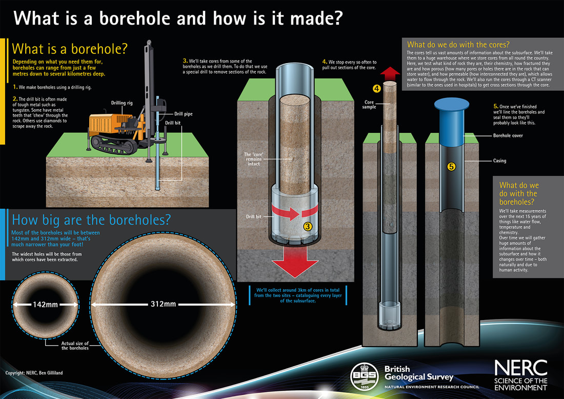
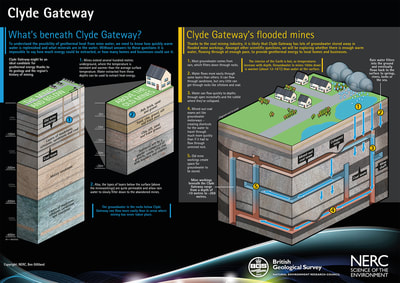
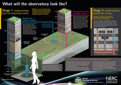
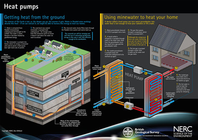
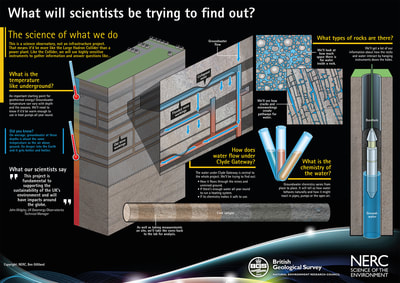
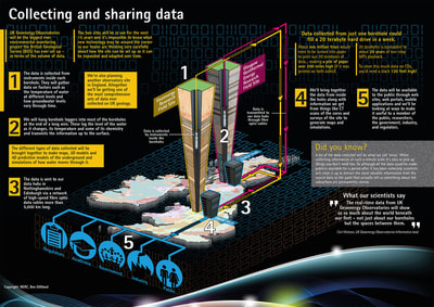
So, if you think your company, institution... or perhaps evil empire... would benefit from Ben's infographics why not get in touch to discuss your needs? Click here to drop Ben an email to start the conversation. Despite having a less than ideal run-in time, this was a really fun project. I was commissioned by NERC (Natural Environment Research Council) and BGS (British Geological Survey) to create a series of large-format posters for a proposed Geoenergy Observatory. The posters were used in two public consultation events in Cheshire and Glasgow (in September 2017) where NERC and BGS representatives addressed any queries, or concerns the public might have about having such a scheme on their doorstep. When complete, the project will consist of about 80 boreholes (of varying depths) each equipped with a variety of equipment and sensors. The boreholes will allow scientists and geoengineers to observe how fluids and gas flow within underground systems and to understand the relationship between the rock layers from the surface to the deep underground environment. Measurements taken from the boreholes will look at issues such as seismic activity, water movement and chemistry. Click the images above to embiggen! Christina Chapman (BGS's project communications manager) said: "I would like to thank you for all the work you did in producing content for our event... there was a lot of work for you and Sylvie to get through in a short amount of time. We’ve had lots of lovely positive comments about the posters – and particularly the boxes. They were great to work with as an interactive device" Infographics are an incredibly powerful tool for communicating complex ideas to customers, the public, or to policy makers.
So, if you think your company, institution... or perhaps evil empire... would benefit from Ben's infographics why not get in touch to discuss your needs? Click here to drop Ben an email to start the conversation. |
Author
Ben Gilliland is a freelance science writer, graphic journalist, illustrator and author with more than 20 years of experience. This is where he talks about work he has done... on the off-chance anyone is interested. Archives
August 2018
Categories |
Proudly powered by Weebly
 RSS Feed